About the Community Hikes Program
The Maine A.T. Land Trust’s Community Hikes program provides free guided hiking trips to the general public from May to October and then from January to April. There are typically two to three hikes per month (depending on weather) and trips are guided by trained trip leaders. The program has been enormously successful at bringing individuals to the A.T. landscape but they can fill up quickly! The limit for participants is usually 5-8 individuals. If a hike you would like to attend is currently filled up, please email us at info@matlt.org to get on the waiting list. Summer hikes will be listed in May, winter hikes will be listed in December, so check back if you don’t see any!
Winter 2026 Update
We are adding more hikes as winter progresses – please continue to check back and sign up for the MATLT newsletter to make sure you know when new hikes are posted!

- This event has passed.
Arnold Expedition Appalachian Trail Hike

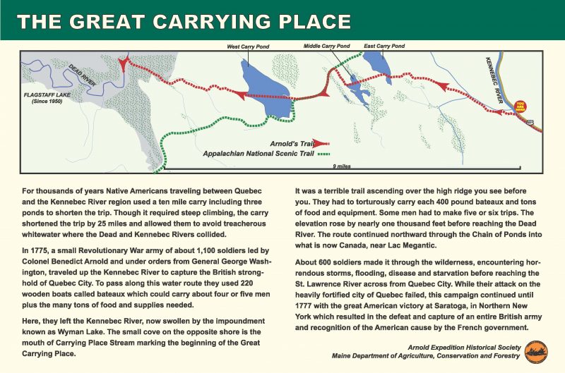
The Maine Appalachian Trail Land Trust is pleased to offer a hike on June 3rd on the original route of the Arnold Expedition to Quebec in 1775 as part of the American Revolution. The expedition followed the Great Carrying Place Portage Trail from the Kennebec River at Bingham west to what was then the Dead River (but is now Flagstaff Lake). Thanks to the efforts of the Arnold Expedition Historical Society, the trail has been revived and there is a map and guidebook. The entire route of the expedition can be more or less followed from the Kennebec to Lac Megantic in Quebec. It is now a National Historic District in the National Register of Historic Places.
Much of the route between the Kennebec and Flagstaff Lake follows the Appalachian Trail, which is why we are pleased to offer this joint AEHS/MATLT hike. We will have as our guide Norm Kalloch, a board member of the Arnold Expedition Society who lives in the area and can provide some detail about the historic locations along the route. He can also show us the way since the route meanders between logging roads, the orange-blazed Arnold Trail and the white-blazed Appalachian Trail.
This hike follows land from the Kennebec River to Arnold Point on the east shore of West Carry Pond. The terrain is generally up and down hills and is not as steep as many areas of the A.T. in Maine. The total distance of the hike will be approximately 10 miles, out and back. This is a moderate hike given the terrain, but the distance is long. If you sign up for this hike, please be prepared to be out all day walking.
Car pooling will be arranged closer to the date. If you would like to come along, please RSVP below or by emailing us at info@matlt.org. You must RSVP in case of time changes or other updates. See you there!
