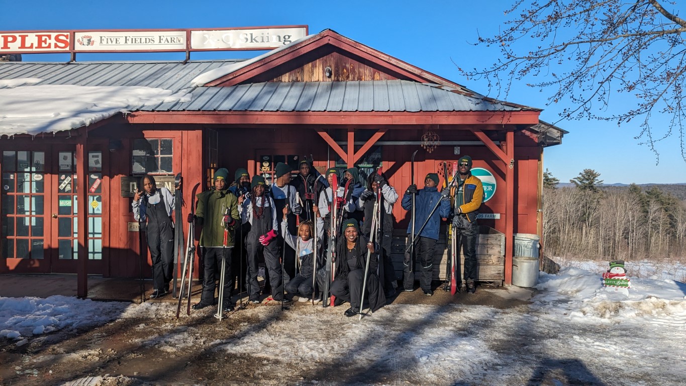
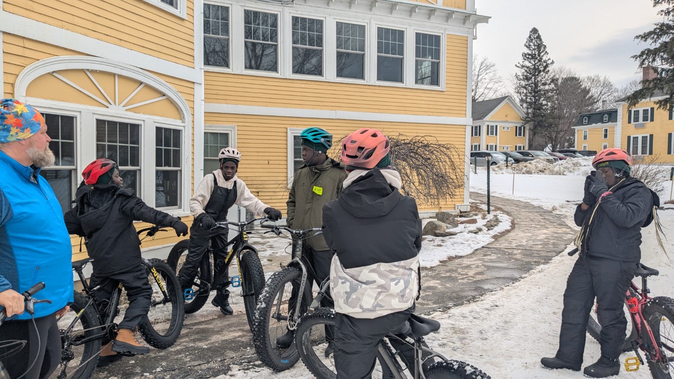
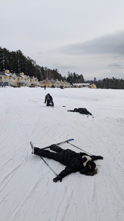
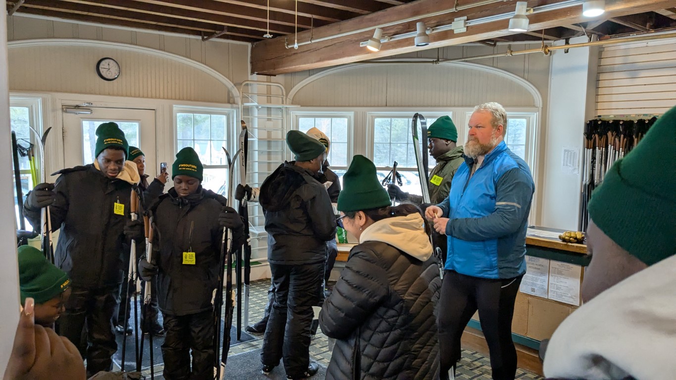
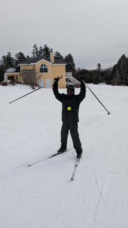
Puzzle Mountain Trip Report

MATLT’s first community hike of 2023 and of the winter season was scheduled for Saturday, January 14, but the weather a few days before and the day of was less than ideal. Fortunately, everyone agreed to postpone the hike and it was worth the wait. Sunday proved to be a sunny, almost bluebird sky kind of day, with moderate temperatures and although a bit windy, nothing to stop three happy hikers from summiting Puzzle Mountain in Grafton Notch.

Puzzle Mountain is part of the Stewart Family Preserve, named after Bob Stewart, who donated the land to the Mahoosuc Land Trust for permanent protection from development. The Puzzle Mountain Trail, part of the Grafton Loop Trail, ascends from route 26 and continues to the open summit of the mountain after passing several ledges with great views of the Bear River Valley, the Mahoosuc Range and the Presidential Range. About 0.1 miles before the summit, there is a sign for the Woodsum Spur trail that branches toff o the right. As expected, the spur was not broken out so was not on our itinerary.

The views from the ledges and the summit were beautiful as promised, but the ascent was slow. Although, micro-spikes were adequate, there was a light covering of crunchy snow that kept us marching along at a slow to moderate pace. Once at the top, and after some obligatory pictures, we sat behind the summit cairn to get out of the wind and enjoyed our lunches. A few other hikers summited while we ate but did not hang around for long. One very friendly hiker did stick around just long enough to take our group picture for which we were grateful. Of course, we returned the favor.

We did not leave the summit until after 2 PM as our ascend was not exactly timely but the trail on the way back was now packed down from our tracks and those of the other hikers. This made for a quick decent and we were down in just over two hours. As we headed down over the ledges, we were treated to the same lovely views but with that late winter afternoon sunlight that is easily more beautiful than any other time of year.

The sun was starting to set as we pulled out of the parking lot, and we were treated to a beautiful sunset. The perfect ending to just about a perfect hiking day.

Stewardship of Lands and Trails 2022

Ready for some trail work on the White Brook Trail.
The view from White Cap Mountain in the Hundred Mile Wilderness.
Sometimes it rains.
Sometimes you have to walk on old roads to get the views.
The Erratic on the Berry Picker’s Trail to Saddleback Mountain.
Mount Abraham in autumn.

The Maine Appalachian Trail Land Trust owns and/or manages nearly 25,000 acres of land (and counting…) along the Appalachian Trail in Maine! We monitor conservation easements, maintain trails, follow boundaries, bushwhack to sensitive ecological areas, climb mountains, and put up signs. It’s a lot of work but we have a great team of volunteers and supporters who make this happen. Check out the gallery above for some highlights of our work in 2022.

New Signs Installed at Saddleback Mountain and Bald Mountain Pond

The Maine Appalachian Trail Land Trust was part of the installation of two kiosks this summer, adding wayfinding in two key locations in order to facilitate public access to lands along the A.T. in Maine. At Saddleback Mountain, hikers have long used a ski trail from Saddleback Maine to reach the summit of the mountain on the A.T. Though this trail is not an official Appalachian Trail side trail it is heavily used and the information on the panel provides information to help hikers protect the sensitive alpine environment on the summit, engage in good practices while exploring, and learn about the A.T. and the lands in Maine’s High Peaks area. Thanks to Maine Appalachian Trail Club, Appalachian Trail Conservancy, Saddleback Maine, FatBird Design and Signworks for helping to get this done.

At Bald Mountain Pond, the land trust received funding through a grant from The Trust for Public Land to install a kiosk on the access road to the pond. It is reached by logging roads which can be difficult to navigate, so this kiosk includes a road map and a description of the landscape. Maine Appalachian Trail Club volunteers provided 66 hours of time in helping to fabricate and install the kiosk, which is located on the Pinkerton Road in Moscow (Maine). If you head to the pond be sure to stop and take a look!

Mapping Maine’s Appalachian Trail: Just Add MATGIC

The Maine Appalachian Trail Land Trust is pleased to announce that the organization is the recipient of a grant from the Land Trust Alliance and the Open Space Institute, the funds from which will be used to incorporate climate science into strategic land protection and stewardship efforts, harnessing the land’s natural ability to capture and store carbon. 

Specifically, these funds will be used for the Maine Appalachian Trail Geospatial Information for Conservation (MATGIC) project, which covers 1,708,013 acres of land within two miles of the Appalachian National Scenic Trail in Maine.  

“The MATGIC project is the best tool we have for analyzing the land along the A.T. in Maine for land conservation. Using this kind of data as the Maine Appalachian Trail Land Trust has put it all together is a way to take advantage of opportunities and also counter threats to Maine’s A.T landscape,” said Peter S. McKinley, land trust board Vice President.

The Land Trust’s work supports the Maine Climate Council’s mission, which includes protecting the state’s environment and working lands and waters as one of eight primary strategies for achieving carbon neutrality by 2045, and decreasing greenhouse gas emissions by 80% by 2050. If these goals are to be reached, the lands along the A.T. in Maine will play a significant role for the people of the state of Maine and beyond. 

In total, the Land Trust Alliance and the Open Space Institute are awarding nearly $400,000 in grants to help communities better plan for climate change and its impacts. This work will enable people, plants, and animals to better adapt to a changing climate. The grants, which have been awarded to 30 nonprofit organizations nationwide, also include nearly $50,000 of direct technical assistance for climate-focused planning and communications. The program is generously funded by Doris Duke Charitable Foundation, J.M. Kaplan Fund, Jane’s Trust Foundation, the Volgenau Foundation, the William Penn Foundation, an anonymous foundation, and several individual donors.

An Appreciation: Tony Barrett

Longtime board member Tony Barrett, who was with the Maine Appalachian Trail Land Trust since its founding in 2002, recently termed off of the board of directors and will now be exploring new adventures. Tony is a former USGS employee who worked for many years as Vice President for Amoco in Australia, Papua New Guinea, Africa and the Middle East. He currently serves on the Executive Committee of the Maine Appalachian Trail Club and as a trail maintainer on the Appalachian Trail. He thru-hiked the A.T. in just prior to that time.

It is a challenge to summarize everything Tony did for this organization but his contributions exemplify the best kind of service that conservation and recreation organizations can hope to get from their supporters. He was happy in the field exploring a remote property in inclement weather, providing expertise from his career but also from his countless hours volunteering for MATC and others. But he was also willing to serve on committees and roll up his sleeves on less exciting tasks like strategic planning or budgets. He was diligent and scrupulous in all matters relating to the governance and direction of the Maine Appalachian Trail Land Trust, always placing the good of the organization in perpetuity over quick options or easy answers.

The organization was happy to provide Tony with a surprise gift of a plaque honoring his many contributions to the Maine Appalachian Trail Land Trust (photo above), but that is a small token of thanks in comparison for all that he has done for the A.T. in Maine. Thank you Tony!

Rangeley Hosts Ten Year Anniversary Trail Town Festival

Rangeley held its tenth annual Trail Town Festival over Labor Day weekend, attracting hundreds of visitors to one of the Maine’s High Peaks region’s A.T. Communities. There are now 51 towns along the Appalachian Trail, in 12 states, that have achieved this designation. These towns and cities are assets for everyone who uses the A.T., providing food, supplies, recreation, history, volunteer opportunities and so much more. There are many benefits for communities who join, including access to educational resources, national and regional recognition of tourism programs, and opportunities for grant funding.

Rangeley holds the annual Trail Town Festival to celebrate not only the A.T. but all the conservation and recreation elements that contribute to the region’s identity. The Maine Appalachian Trail Land Trust annually attends and distributes free maps, information about trails, and more, but there are dozens of vendors and other organizations around to make it a truly special experience. There’s music, guest speakers, games for kids, and of course…thru hikers. At the end of the day there’s an ice cream eating contest so they can head back to the trail fattened up for the last leg of their journey to Katahdin. There’s also a kids version of the contest so they don’t feel left out!

Check the festival info page next year for info about attending!

Maine A.T. Land Trust Welcomes Two New Board Members

The Maine Appalachian Trail Land Trust is pleased to welcome two additions to the Board of Directors!  Sasha Nyary (left) is a writer and editor who has lived almost her entire life in cities. In 2020 she was based in Holyoke, Massachusetts, when the pandemic allowed her to work remotely. So she moved to Maine to be with her wife in New Gloucester. She started a communications business, became a member of the Executive and Marketing committees at the Maine Appalachian Trail Club, and is learning to fish.  Sasha comes to the organization through its connection to the Maine Appalachian Trail Club (MATC) which is the volunteer nonprofit corporation responsible for the management, maintenance and protection of the A.T. in Maine.

We are also pleased to welcome Lucy Santerre (right).  Lucy also moved to Maine in 2020, to work one season on a small organic farm, but the beauty of the A.T. and its surrounding trails near the Hundred Mile Wilderness convinced her to stay. She currently works in development and communications for the York County Domestic Violence Resource Center and provides programmatic support at the American Philosophical Association. Lucy lives with her husband at the beach in southern Maine.

Both of Lucy and Sasha have hit the ground running and will be involved in helping the Maine A.T. Land Trust with development, marketing and communications.  Both are also eager to get out in the wonderful places in the A.T. region of Maine and help with trail maintenance, stewardship and land management responsibilities!

The Maine A.T. Land Trust is always looking for volunteers to help protect land along the A.T. in Maine for public benefit.  We have trail maintainers, land stewards, attorneys, planners, graphic designers, fundraisers, foresters and retirees who help with this work.  If you are interested in joining us, reach out at info@matlt.org or 207-808-2073.  Whatever your skillset or interest, we can make it work!

Winter Hikes Update: How to Get Out in the A.T. Landscape Safely

As we close out the warm season and start digging through our closets looking for winter hats, gloves, goggles, microspikes, boots, soft shell pants, long underwear, snowshoes and more, the Maine A.T. Land Trust wanted to provide an update on our Winter Community Hikes program and also send out some guidelines for recreating safely during winter on trails in the Appalachian Trail region of Maine.  Winter is a fantastic time to be out – there’s the sense of solitude, the stark beauty of a snowy forest, the quiet of dampened noises, and the lack of crowds on trails.

First, the bad news: as with was the case during the summer, this organization will not be able to run our Winter Community hikes program during the current COVID-19 pandemic.  Cases continue to rise and the logistical hurdles to running our hikes are still present.  With the rise of community spread and the falling temperatures, many of the practices that might have been viable during the summer (sharing a vehicle over short distances while wearing a mask) are no longer practical.  This is not a decision the board of directors takes lightly.  We value engagement with the outdoor recreation community in all its forms and cancelling this program takes away one our our best tools for doing so.

At the same time, we want to encourage everybody to get out on the trails this winter – in a safe manner – as much as you can.  To help this we wanted to post some guidance on how you do so, with the understanding that these are best practices only and you should always, always check with trail managers, land trusts and state agencies on what to do.  We will also be sharing any applicable information from them as it becomes available.

Here are some guidelines for getting out there this winter:

  1. Make sure your trail is open.  Check in on Maine Trail Finder to confirm – don’t assume that one trail is open because another is.
  2. Prepare.  During the pandemic, take extra precautions.  Unless you are hiking with household members or those you are podding with, it can be difficult to maintain adequate distance on a trail.  You absolutely do not want to but yourself or others in danger by needing outside personnel to aid you in the backcountry.
  3. Do not hike alone.  Things are different in the winter – you will probably not survive an unplanned night out in a remote area as you would in the summer.  Even something simple like a dead car battery can turn into a desperate situation during the winter hiking season.  Be prepared for every eventuality.
  4. Do not carpool.  Unless with your household – with is the recommended way to recreate this season.
  5. Do not plan a large hike with ten friends where all of you are driving separately.  Aside from the environmental impact without carpooling, Maine A.T. trails are generally not as accessible during the winter as they are during the summer.  Many parking areas are not plowed, pull-over spots have limited space and in some places you have to park much further from the trailhead than in warmer months.  With too many cars you will run the risk of not having room for all your party.  This is also a courtesy to other hikers – do not take all the parking for your group alone.  Others want to hike too!
  6. Stay close to home for most hikes.  Trails closer to towns are usually less crowded during the winter anyway!  And you won’t have to circulate in gas stations, rest areas and food stops in remote locations that might be limiting services to stop the pandemic.

Following these guidelines and others from your state and local health agencies will ensure that you can still get out in the winter – and we’ll all need to – while making sure that you and those close to you stay safe.

In the meantime, keeping checking our Hikes page for new StoryMaps on great places to head out this winter!

Get Outside for Physical and Mental Wellbeing – Safely!

For Immediate Release
May 20, 2020

Media Contacts
Warren Whitney, Maine Coast Heritage Trust, wwhitney@mcht.org
Jeremy Cluchey, The Nature Conservancy in Maine, jeremy.cluchey@tnc.org
Jim Britt, DACF, jim.britt@maine.gov

Get Outside for Physical and Mental Wellbeing but do it Safely.

AUGUSTA, Maine – Biking, boating, hiking, fishing, birdwatching, and other outdoor activities are great ways to stay healthy in the age of COVID-19 – provided they are conducted in accordance with all public health restrictions and guidance. As summer weather is fast approaching, Maine’s conservation and recreation communities, natural resource agencies, and outdoor brands developed the following checklists to help us all enjoy Maine’s outdoors in ways that are safe and responsible during this difficult time. Before you hit the trail, cast a line, or launch a canoe, please be sure to:

Find the Right Time and Place

Know What’s Available: Consider visiting a nearby Wildlife Management Area, or a less-trafficked state park, public land, or local land trust (Maine Trail Finder is a great resource!)
Check before you go: While some popular conservation lands have closed recently due to overuse and crowding, the vast majority remains open to the public. Visit websites to see the latest information on closures or conditions. Please respect all property closures.
Have a plan B: If the parking lot is full, the destination is too crowded. If your first destination has a busy parking lot, go to the next spot on your list!
Avoid peak times: Get out earlier or later in the day.

Be Prepared Before Heading Out

Expect limited services: Facilities like public restrooms could be closed, so plan accordingly.
Dress for success: Be aware of current conditions and bring appropriate gear to match those conditions. Local outdoor brands are open for online sales and are available to give advice on appropriate gear and equipment.
Support local businesses: Many local businesses – from restaurants and retailers to guides and lodges – are working hard to provide services in ways that are safe and in keeping with public health rules and guidance. If you’re comfortable, consider finding ways to support them while you’re enjoying the outdoors.
Don’t take risks: Stick to familiar terrain and avoid unnecessary chances to avoid injuries, which add stress on first responders and medical resources.
Be aware of the rules: Check before you go to see what activities are allowed. If dogs are permitted remember to bring a leash and to properly dispose of waste.
Watch out for ticks and biting insects: Wear light-colored pants, closed-toe shoes, and apply EPA-approved bug repellent.
Leave home prepared with sanitizer and disinfectant.

Heed All COVID-19 Health Warnings

Practice social distancing: Stay at least six feet away from other people who do not live in your household. If necessary, step aside when passing other people on the trail.
Don’t linger: Shorten your stay when visiting natural stopping points such as waterfalls, summits, and viewpoints so everyone can enjoy them while maintaining a safe distance.
Bring a mask: When you’re in the vicinity of others, even with six feet of separation, a mask will help keep everyone safer.
Don’t touch: Avoid touching signs, kiosks, buildings, and benches to minimize the potential spread of the virus.
If you’re sick, stay home: It puts others at risk when you leave home while exhibiting symptoms related to COVID-19, or if you have recently been exposed to the virus.
If we all follow these guidelines and put public health first, we can enjoy Maine’s natural resources in safe and responsible ways as we work through this difficult time together.

In Memoriam: Dr. George N. Appell (1926-2020)

George being presented the Maine Appalachian Trail Club Lone Mountain peak sign in 2018 by land trust President Bill Plouffe. (Tony Barrett photo)

Note:  The Maine Appalachian Trail Land Trust recently lost one of its board members, George Appell.  George had a tremendous impact on the organization and conservation efforts in the Appalachian Trail region in Maine.  Rather than summarize his life, we’ve chosen to share reflections from those on our board who knew him well.

Tony Barrett

I met George at his first Maine AT Land Trust Board meeting, accompanied by his wife Laura. In the early Board meetings, there were a number of husband/wife teams who attended meetings (i.e. Dean & Shelia Bennett and Dain & Vera Trafton) so important to getting the land trust off the ground.

George lived in Phillips which is very close to the section of the Appalachian Trail that I have maintained for the last 20 years. George was very interested in the A.T. (hence his interest in joining the land trust Board) and we would chat about the latest trail community news. I often would copy him on my MATC trail work reports. From early prioritization work, the land trust focused on priority blocks in the High Peaks.  When the 1,200-acre Ridge/Lone Mountain parcel just missed Forest Legacy funding in 2009, George personally stepped up to purchase the parcel from Wagner/Bayroot. He set up a conservation organization to manage the land (he later transferred ownership to the Northeast Wilderness Trust).  As I conducted boundary monitoring (the Ridge parcel abuts the A.T. corridor for almost a mile) I would copy George on my monitoring reports. On several occasions, I would stop by his house (since he lived so close) and we would talk about the trail and this parcel in particular.  I don’t believe that George ever visited this land parcel.  I created a map and a series of photos so that he could take a ‘virtual’ walk-about on the critical land that he was protecting.

This is George’s Mountain Conservancy sign posted on the Lone Mountain parcel. (Tony Barrett photo)

George’s sister, Helen Norton, lives in Harpswell (my hometown).  She is also very involved with land conservation where I got to know her through various projects in town and the Harpswell Heritage Land Trust. George also had a Harpswell connection through his ownership of a small island in Middle Bay.  George would migrate to Harpswell in the Fall to observe the seasonal hawk migration along the coast – he seemed to me to be an avid birder. My one regret is that I never accepted George’s invitation to join him on the island to watch the hawks.  He may be flying with them now.

Pete Ventre

I will miss George. I knew George professionally as well as personally through the Land Trust. I will especially miss our conversations often over lunch in Portland. George was exceptionally curious. He could engage in conversation knowledgeably on most any topic.  He was a most kind hearted and generous person as anyone who knew him would testify. He and Laura had a truly special relationship as they shared their work and were never apart.  She would happily accompany George to the Yukon or Borneo with enthusiasm.  I always enjoyed being with them together.  Yes, I will miss him.

Bill Plouffe

George was both a generous philanthropist and a conservation philosopher who offered an important and distinct voice in the conservation conversation.


Lloyd Griscom

George Appell was a friend who cared deeply about nature and biodiversity and ecology, but he cared mostly about results. Having helped the Maine A.T. Land Trust through a period of transition, the following graph shows why he was proud of helping the Maine A.T. Land Trust achieve these results:

Pete McKinley

I will miss George’s curiosity about the living world around us, whether insects, birds, plants or people, whether near to us in Maine or in far off islands and waters, he wanted to understand and he wanted to conserve the diversity of life in all its expression.  This was clear in his life’s work and in the course of many spirited conversations.  He sought to understand nature and take action to conserve nature and leaves us with inspiration to keep asking questions and keep taking the bold and creative action needed.


Simon Rucker

George Appell grew up on a farm in York, Pennsylvania, and was a world-renowned anthropologist specializing in research on Borneo.  He held two advanced degrees from Harvard University and lived in Phillips, Maine.

George’s bio, which appears elsewhere on this website, is brief but underscores what everybody who met him came to understand: George’s ideas and accomplishments were so big that no description I write can really do them justice.

George joined the Board of the Maine A.T. Land Trust in 2009 and, with his wife Laura, had an immediate impact on the direction of the organization right up until his passing.  When I became Executive Director in 2014 one of the first things the organization did was to pass a resolution in support of climate corridors, climate refugia, and ecological diversity and connectivity.  This was largely at George’s behest.  At that time these were still relatively new concepts; the conservation world did not begin to follow his lead for a period of years.

George was also a stalwart champion of biodiversity on a global scale, having seen the destruction of forests in Borneo when he was working as an anthropologist with the Rungus Momogon people.  This focus served to remind the Maine A.T. Land Trust of the larger implications of our conservation efforts here in Maine.  We might be working to protect a 5,000-acre forested property in the High Peaks, but the ecological values here are tied to a larger world of biodiversity, world ecosystems, and the web of life that surrounds us.  George was a constant champion of these and they are permanent fixtures in the strategies the organizations uses to protect land.

Despite George’s accomplishments, he was an easy person to be around.  When I first met him (and Laura) in their living room we sat for four hours.  Yes, we discussed land conservation and the direction of the Maine A.T. Land Trust, but the bulk of the time was devoted to storytelling.  I spent many afternoons in that living room or in George’s office discussing current conservation projects but mostly just talking about whatever we felt like talking about.  Sometimes we agreed on things, sometimes we didn’t, but it was always time well spent and you knew that spending the afternoon with him would make you a better person.

One of the great regrets we all have in life is when somebody we know passes away without having told us a story.  George and Laura’s house was filled with artifacts from their adventures, all of which told such stories, some of which most of us will never get to hear.  A photo of them on the MacKenzie River, a place which is still remote and inaccessible to most people but one to which they traveled to in 1957.  A poster-sized map of Borneo (in Dutch) which inspired George to say, “Remind me to tell you something about that map.”  His office, which was filled with more books per square foot than any library I had been inside of.  His rifle hanging over the doorway.  All of these things were loaded with stories that I will no longer get to hear.